

Tucked into the northeast corner of Church Bay and enclosed behind substantial breakwaters, the harbour provides good shelter and protection from all winds northwest through east to south-southeast. The clear bay provides safe access in all reasonable conditions at any stage of the tide by a well-dredged entrance channel supported by leading lights.


Keyfacts for Church Bay
Facilities


Nature


Considerations


Protected sectors

Approaches

Shelter

Last modified
May 8th 2023 Summary
A good location with safe access.Facilities
Nature
Considerations
HM  +44 2820768525 HM
  +44 7803505084
  john.morton@causewaycoastandglens.gov.uk
  Ch.80 / 16 [Ballycastle Harbour Master]
+44 2820768525 HM +44 7803505084 john.morton@causewaycoastandglens.gov.uk Ch.80 / 16 [Ballycastle Harbour Master] Position and approaches

Expand to new tab or fullscreen
Haven position
 55° 17.503' N, 006° 11.658' W
This position is at the southern end of the deep water pontoon. This pontoon lies inside the outer breakwaters in the centre of the harbour.
What is the initial fix?
The following Church Bay Initial Fix will set up a final approach:
 55° 16.971' N, 006° 12.176' W


What are the key points of the approach?
Offshore details are available in northeast Ireland’s Coastal Overview for Malin Head to Strangford Lough  .
.
.- Pass the Drake Wreck South Cardinal 200 metres off on either side and proceed to the harbour.
Not what you need?
Click the 'Next' and 'Previous' buttons to progress through neighbouring havens in a coastal 'clockwise' or 'anti-clockwise' sequence. Below are the ten nearest havens to Church Bay for your convenience.
Ten nearest havens by straight line charted distance and bearing:
- Ballycastle - 5.3 nautical miles SSW
- Murlough Bay - 5.6 nautical miles SSE
- Ballintoy Harbour - 6.5 nautical miles WSW
- Torr Head - 7.4 nautical miles SE
- Portbraddan - 8.1 nautical miles WSW
- Cushendun - 11.2 nautical miles SSE
- Portballintrae - 12.9 nautical miles WSW
- Cushendall - 13.9 nautical miles SSE
- Red Bay Pier (Glenariff Pier) - 14.4 nautical miles SSE
- Portrush Harbour - 16.7 nautical miles WSW
These havens are ordered by straight line charted distance and bearing, and can be reordered by compass direction or coastal sequence:
- Ballycastle - 5.3 miles SSW
- Murlough Bay - 5.6 miles SSE
- Ballintoy Harbour - 6.5 miles WSW
- Torr Head - 7.4 miles SE
- Portbraddan - 8.1 miles WSW
- Cushendun - 11.2 miles SSE
- Portballintrae - 12.9 miles WSW
- Cushendall - 13.9 miles SSE
- Red Bay Pier (Glenariff Pier) - 14.4 miles SSE
- Portrush Harbour - 16.7 miles WSW

Chart

What's the story here?
 Church Bay Harbour
Image: Olivier Riché via CC BY-SA 2.0
Rathlin Island, with a population of around 150 people, is the most northerly inhabited island off the coast of Ireland and the only inhabited offshore island of Northern Ireland. With its southern extremity about 2 miles northwestward of Fair Head, the sizable island is four miles from east to west and 2½ miles from north to south and is shaped in what can be best described as a 'boot' with its toe pointing southward. The island stands proud, composed of high tablelands of 137 metres in elevation, surrounded by precipitous cliffs. At the head of its southwest-facing Church Bay is the island harbour and principal settlement from which ferries servicing the island run to Ballycastle on the mainland. The small harbour is protected by two substantial outer boulder-based breakwaters. Within this is a small enclosed inner harbour and pontoons for visiting craft.
 Visitor Pontoon in Church Bay Harbour
Image: © Gordon Dunn
Three finger pontoons are available that can accommodate up to 40 visiting boats. The approaches have a least depth of 2.8 metres LAT and the outer, southernmost ends, of the pontoons, should have 2.4 metres LAT which progressively reduces to about 2.00 metres LAT down either side. But do not rely on it as silting could occur and it is best to take the latest advice from the Harbour Master.
 The harbour pontoons can accommodate up to 40 visiting boats
Image: Michael Harpur
The harbour is operated by the Ballycastle Harbour Master John Morton and all visiting vessels must book in advance and will be asked to pre-pay, prior to arrival. The Harbour Master can be contacted for bookings, at Rathlin,
80 / 16 [Ballycastle Harbour Master], +44 (0)7724594118, john.morton@causewaycoastandglens.gov.uk or at Ballycastle Marina on +44 (0)28 207 68525 / +44 (0)7803 505084. Anyone requiring fuel must also book it in advance with the Harbour Master.  The Rathlin Island Ferry manoeuvring in the inner harbour
 Image: Tourism NI
Provided the Harbour Master grants permission it may also be possible to come alongside Manor House Pier for a short period but do not impede the island’s ferry. Likewise, it may also be possible to use the 30 x 100 metres long inner harbour that has 1.7 meters MLWS.
 The head of Manor House Pier
Image: Tourism NI
It is also possible to anchor in the northwest section of the harbour, behind the north breakwater, but beware there may be insufficient depth at LWS and be particularly guarded should a southern wind swing the vessel inshore. Likewise do not anchor so far out as to obstruct the Ferry. Once again contact the Harbour Master directly for the best depth information. In all cases, vessels moored inside the harbour breakwaters are subject to harbour dues if collected.
 Schooner anchored outside the entrance in Church Bay
Image: Tourism NI
With winds anywhere northward, or eastward, a good summer anchorage can be had outside the harbour's north breakwater as the depth of water is moderate but the holding is not so good. Anchor as convenient in about 5 metres of water but test the holding well as the bottom of rock and weed does not offer the best holding.
How to get in?
 Rathlin Island as seen from Fair Head
Image: Aidan McMichael via CC BY-SA 2.0
 Offshore details are available in northeast Ireland’s coastal overview for Malin Head to Strangford Lough . Rathlin Island is situated 5 miles off the coast opposite Ballycastle Bay located on the mainland between Kinbane Head and Fair Head. The high island is surrounded by precipitous cliffs of trap and white limestone, that mirror the appearance and structure of the opposite mainland shore. The coasts of Rathlin Island are clear of hidden dangers beyond the distance of 350 metres.
  Rue Point and Fair Head with Torr Point in the backdrop
 as seen from the west end of Rathlin Island
Image: Archibald via CC BY SA 3.0
The high island is unmistakable in daylight and at night it has a lighthouse on all three of its points:
 Rue Point Lighthouse
Image: Tourism NI
Rue Point Lighthouse stands on the southern portion of the island which is broken into hummocks that gradually decline towards Rue Point, the low and rocky southern extremity. Rue Point Lighthouse is a white octagonal concrete tower, with two black bands, 11 metres high and it stands 2¼ miles north by west from Fair Head.
Rue Point Lighthouse - Fl (2) 5s 16m 14M position: 55° 15.533’N, 006° 11.474’W
 Rathlin West Lighthouse situated ½ mile north of Bull Point
Image: Tourism NI
The upside-down Rathlin West Lighthouse, or The Bull Lighthouse, stands at an elevation of 62 metres on the west side of the island marking Bull Point. Set into the side of the island's western cliffs, about a ½ mile north of Bull Point, Rathlin West comprises an 18-metre high white tower that has an unusual red lantern at its base.
Rathlin West (The Bull) Lighthouse - Fl R 5s 62m 22M position: 55° 18.052’N, 006° 16.815’W
 Rathlin West showing its unusual red light from its lantern at its base
Image: Tourism NI
Rathlin East Light is situated on Altacarry Head, the northeast point of Rathlin Island. It stands, at an elevation of 74 metres and is a 27 metres high white tower with a black band.
Rathlin East (Altacarry Head) Lighthouse - Fl (4) 20s 74m 26M position: 55° 18.111’N, 006° 10.313’W
 Rathlin East Light is situated on Altacarry Head
Image: Olivier Riché via CC BY-SA 2.0
On a final note, mariners should be aware that the North Channel Traffic Separation Scheme lies just 2 miles to the northeast of Altacarry Head.
 The North Channel TSS lies just 2 miles to the northeast of Rathlin Island
Image: James T. M. Towill via CC BY-SA 2.0
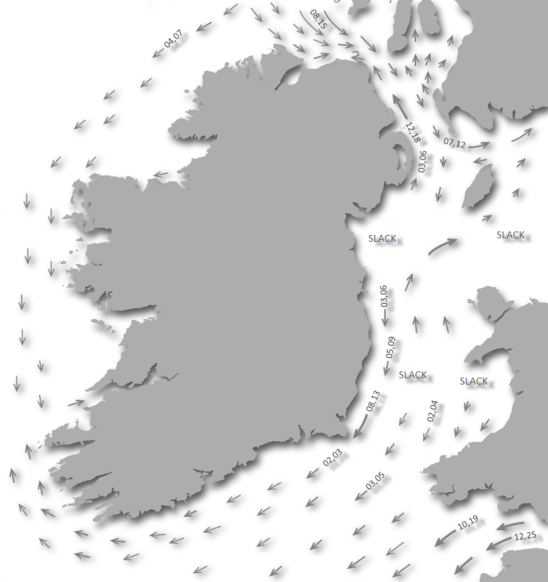
The direction and velocity of the tide should be the central feature of any navigation planning as the island is subject to strong tidal streams with overfalls. In the centre of the North Channel, the flood tide runs southwards, commencing at -0600 HW Dover and the same can be taken for HW Belfast as there is scarcely 10 minutes difference between them. The ebb northwards, +0100 HW Dover/Belfast with spring rates that can attain 3.5 knots. The roughest water may be experienced between Fair Head and Torr Head, where just off the point of Torr Head the Ebb runs up to 6 knots during Spring tides.
The tides in Rathlin Sound are very strong, have several eddies and are subject to great variations both in force and direction. Tides run from up to 6 knots at springs, to 4 knots at neaps causing strong eddies along the shores, with heavy overfalls off all the headlands, the MacDonnell Race at the northeast corner is particularly fearsome.
 The position of Slough-na-more as seen from Fair Head
Image: Tourism NI
The most dangerous race however is Slough-na-more with its name derived from the Irish 'Sloch na Marra' meaning 'Valley of the Sea'. It is situated to the east end of Rathlin Sound about 1 mile southwest of Rue Point and is clearly marked on the Admiralty chart. Violent overfalls occur here during the full strength of the west-going stream between +0130 and +0230 HW Dover/Belfast. After this, the overfalls slowly subside to ripples on the surface. It can be dangerous in a west-going stream against a westerly wind or swell. During gales, the overfalls break heavily and should be avoided.
Rathlin Sound's west-going stream commences at HW Dover/Belfast and runs for 5 hrs. As from 1 hr after HW Dover/Belfast east-going eddies develop between Fair Head and Ballycastle and further west. The main west-going stream and eddies reach their strongest rates during the 2nd and 3rd hrs after HW Dover/Belfast. The east-going stream commences at -0500 HW Dover/Belfast. A west-going eddy develops between Ballycastle and Fair Head as from -0400 HW Dover/Belfast continuing until-0100 Dover/Belfast.
This said, if the tides have been well studied and embraced, a well-found yacht should have no difficulty sailing this area in conditions up to Force 4 or 5. And once within the heads of church bay, the tide is scarcely precipitable. The tides can also be availed of to expedite a passage and the best westbound passage through Rathlin Sound should be timed to commence at +0340 HW Dover/Belfast. The best eastbound passage should be timed to commence at +0610 HW Dover/Belfast which will also provide six hours of a south-going tide in the North Channel.
 The harbour as seen from the Drake Cardinal Buoy
 Image: © Super tourist
Church Bay is located in the bight formed by the southwest shores of Rathlin Island, between Bull Point and Rue Point. With the exception of the wreck of the Drake situated a ½ a mile southwest of the entrance, the immediate approaches to Church Bay are clear of offshore dangers. The wreck presents no issue to leisure craft as it has a least depth of 8 - 6 metres over it and it is well-marked by a lit cardinal buoy that can be passed on either side.
Drake Wreck South Cardinal - Q (6) +LFl 15s position: 55° 17.093’N, 006° 12.488W
 The outer rock pile breakwaters
Image: Aidan McMichael via CC BY-SA 2.0
 The Church Bay initial fix is approximately halfway between the Drake Wreck South Cardinal Buoy and the island’s western shoreline. The initial fix is set in the leading light alignment midway between the cardinal and the shore to the east.
 This light is positioned within the village near the Manor House Hotel Oc.WRG.4s, Green 020°- 023°, White 023°- 026°, Red 026°- 029°. At night track in on 024°T, or within the white sectors 023° - 026°, for a ½ mile to the entrance to the outer harbour. The light at the end of North Breakwater (The Bow), FlR 2s 5.3m 3M, the South Breakwater: Fl(2) G6s 3.5m 3M. These are arms of rock armoured breakwaters that project south by southeast and northwest from the shores at the head of the bay. Pass between the pier heads, where a maintained LWS depth of 3.5 metres will be found, and enter the harbour.
Vessels approaching from the west or in daylight may ignore the initial fix and freely approach the harbour keeping 300 metres off the shores of Church Bay.
 Rathline Island's harbour area
Image: © Gordon Dunn
Once inside these substantial breakwaters a vessel may elect to berth at the pontoon immediately within, lay alongside the pier or anchor off as detailed above.  The inner harbour area and the three finger pontoons
Image: © Gordon Dunn
The best pontoon berths are on the north side of the long pontoon, or on the middle pontoon. Those berthing on the southeast side should keep close to the pontoon as it quickly shallows about 20 metres out from the pontoon. The inner sections of the pontoons have reduced depths and are only suitable for shallow draft vessels.
Why visit here?
Rathlin Island, derives its name from the Irish 'Reachlainn', pronounced 'ragh-lin', also often called 'Reachrainn' or 'Reachra'. Many Irish islands use this name but the origin of the word remains obscure. It has been suggested that the name comes from the Celtic word 'rhygnu' meaning 'to rub/scrape', and this could relate to the island's 'rugged' nature and or the ripping tides that race past it. Contested Rathlin as seen from Bengore Head with Scotland in the backdrop
Image: Urbancowboy 89 via CC BY-SA 3.0
Rathlin's history of habitation goes back to the ancient Mesolithic and Neolithic periods in which it played a significant part. Brockley, situated about halfway towards the west lighthouse, was the site of a remarkable Neolithic Stone Age axe factory. Similar to Tievebulliagh mountain near Cushendall, the geology here features an extremely tough porcellanite rock that was capable of taking a keen edge. This made it the preferred Neolithic material for arrows, spearheads and above all axes employed in the forest clearances at this time.
 Malone Hoard Neolithic axes dating to 4,500-2,500 BCE
Image: Notafly via CC ASA 3.0
More than 10,000 beautifully polished and highly distinctive Antrim porcellanite axes have been discovered to date throughout the British Isles, Europe and as far away as Greece. A rich example of these axes uncovered near Malone Road in Belfast can be seen in the city's Ulster Museum. Called the 'Malone Hoard', the collection consists of 19 polished Brockley or Tievebulliagh porcellanite axes that were uncovered and inserted upright. These axes were too big and heavy for practical use and it is thought they were used for ceremonial purposes.
 St Thomas' Parish Church overlooking the harbour today
Image: Heather Cowper via CC BY-SA 2.0
To the north of Brockley, there is an ancient earthwork known as Doonmore. The name is derived from the Gaelic words 'Dùn Mòr' meaning 'great fort' which indicates that it was the site of an ancient defensive settlement. Rathlin's presence was noted in Roman times. Pliny referring to 'Reginia' and Ptolemy to 'Rhicina' or 'Eggarikenna'. In 580 AD, a monastic site was established by St Comgall at 'Church Quarter' on the site of St Thomas’s Church of Ireland. In the following century, in 635 AD, Segene, abbot of Iona, established a Church here as Rathlin came under the care of Iona. The island was certainly a haven for monks at this time as is evidenced by its number of monastic sites: 'Cill Bhride' at Ballygill, 'Cill na Bhruain' in Knockans, where the monk’s or saint’s seat is still visible, 'Cill na Bhruain' in Carrivindoon, and 'Kilpatrick' as well as its 'Knockans' remains of a 'sweathouse' that was an early type of sauna. But Rathlin was not destined to be a safe abode for the monks and a few others who sought sanctuary here.
 Today Rathlin is a place to slow down and adopt the island pace
Image: Tourism NI
From early Christian times onward Rathlin was subject to several bloody massacres. Being situated a mere 25 km from the Mull of Kintyre, the southern tip of Scotland's Kintyre peninsula, and between Ireland and Scotland in the North Channel, the island's strategic position has caused Rathlin's history to be a tale of conflict. It has been successively conquered and reconquered by the Vikings, Scots, Normans and English.
 Rathlin Harbour
Image: Brian O'Neill via CC ASA 3.0
The recorded turmoil commenced in 795 AD when Rathlin was the first place in Ireland to be raided by the Vikings. Their raid was marked by the pillaging of the island's church and the burning of its buildings; as noted in the 'Annals of Ulster' "The burning of Reachrainn by plunderers; and its shrines were broken and plundered". This brief visit set a pattern that was to go on for years along the coastlines of the British Isles.
 The Georgian Manor House building overlooking the inner harbour date from the
late 1700s
Image: Tourism NI
In 1306 Robert Bruce, King of Scotland and compatriot of William 'Braveheart' Wallace, was given refuge in Rathlin castle, and in times of danger legend has it, he was secreted in a black basalt cavern on the northeast point of the island now known as 'Bruce's Cave'. This was after his defeat by the English at Perth and at the time the island was then owned by the Norman Irish Bissett family. It is said that the dispirited warrior watched a spider repeatedly trying to reach the roof of the cave by its thread. Eventually, it succeeded.
 Islander pots in the inner harbour
Image: Tourism NI
From the spider’s perseverance he coined the expression 'if at first you don't succeed, try, try and try again' and the dejected Bruce was inspired to return and win back his kingdom. With renewed determination, he returned to Scotland to gain the throne at the battle of Bannockburn. The English, who were in control of the Earldom of Ulster, later dispossessed the Bissetts of Rathlin for sheltering Bruce. The cave where he is said to have stayed is beneath the East Lighthouse on Altacarry Head, at the northeastern tip of the island.
 Ruin near the harbour
Image: Tourism NI
In the 16th century, Rathlin came into the possession of the MacDonnells Clan of Antrim who attracted horrendous massacres to the island. In 1575 the clan were at war with the English in Ulster and they sent their women, children and elderly to Rathlin Island for safety. In July 1575 Sir Henry Sidney the Earl of Essex sent Francis Drake and John Norreys to confront Scottish refugees on the island. They slaughtered the entire Clan MacDonnell population of 600 mostly women and children. This included the entire family of 'Somhairle Buidhe', better known as 'Sorley Boye' MacDonnell, the clan leader. Essex boasted in a letter to Francis Walsingham, the queen's secretary and spymaster, that Sorley Boy MacDonnell watched the massacre helplessly from the mainland and was 'likely to run mad from sorrow'.
 The view southwards towards Ballycastle
Image: Tourism NI
The Elizabethan policy of massacring civilians, such as in this case on Rathlin Island, left a legacy of bitterness and mistrust. Add to this her government policies of shiring territory in Connacht and Ulster, reorganising Gaelic lordships with redistributions of land and power, and it was not long before it precipitated the major conflict known as the Nine Years War (1593 – 1603) that eventually affected most of Ireland.
 Rathlin Island Seals
Image: Tourism NI
Sorley Boy would have his revenge under his leadership the clan sacked Carrickfergus and largely pushed back the English influence to a few core strongholds. Again, in 1597, amid the Nine Years War, Sorley Boy's nephew James MacSorley, with military support from the forces of Hugh O'Neill, earl of Tyrone, would also take Carrickfergus castle and its town. Still seating from the Rathlin massacre he had the recently appointed English governor of Carrickfergus Castle, John Chichester's head cut off, packed in a barrel and sent to the earl of Tyrone as a trophy.
 Puffins, choughs, guillemots and razorbills nest on the cliffs and sea stacks in
the summer
Image: Tourism NI
Later, in 1642, the MacDonnells were back on Rathlin Island only to be butchered by their Scottish enemies, the Campbells. The Campbells were at war with their arch enemy the Clan MacDonald in the highlands of Scotland. Encouraged by their commanding officer, Sir Duncan Campbell of Auchinbreck, they decided to take the war to their Antrim near relatives. This they did with ruthless efficiency in Rathlin throwing scores of MacDonald women over cliffs to their deaths onto the rocks below. The number of victims of this massacre has been put as low as one hundred and as high as three thousand. Rathlin was deserted for many years afterwards and the cliff face where it took place was known as the 'The Hill of Screaming' from that day onward.
 Drystone wall Rathlin Island
Image: Tourism NI
Between these horrendous massacres, and in stark contrast, was the oddest national ownership dispute of 1617. In that year Rathlin Island was the subject of a legal dispute over where the island's national ownership resided, as part of Scotland or Ireland. It was found to be Irish on the peculiar basis that there were no snakes on the island. As St Patrick was firmly believed to have banished all snakes from Ireland in the 5th Century it, therefore, had to be Irish.
 Southbound road, Rathlin is a hikers paradise
Image: Tourism NI
Being at the head of the North Channel the seas around Rathlin were lively during the two world wars. Some 40 sea wrecks are to be found in its surrounding waters with the most famous being the HMS Drake. HMS Drake was one of the fastest and heaviest cruisers of her time. Early on October 2nd, 1917 whilst escorting a transatlantic convoy from America to the United Kingdom, Drake was hit by a torpedo from the German U-Boat U-79 off the northwestern tip of Rathlin Island. Nineteen crewmen were killed in the explosion but the Drake managed to limp into Church Bay.
 Fair Head as seen from Rue Point Rathlin Island
Image: Tourism NI
It was possible that she was going to be beached in Church Bay but the damage caused her to list considerably and she sank in some 18 metres of water albeit not taking any more crew with her to the bottom. The Drake south cardinal buoy marks the location today and the vessel is too deep to be a danger for leisure craft. But this can not be said for commercial shipping, as on the 4th November 1962 while leaving Rathlin the 595 ton 170 ft trawler 'Ella Hewitt' hit the wreck and sank adjacent to her.
 Storytelling, song, and music flourish on Rathlin
Image: Tourism NI
Today Rathlin is a peaceful and beautiful island with a distinctive landscape and way of life. One of forty-three Special Areas of Conservation the land is a mosaic of heath, grasslands, mires and ponds. It has scarcely any trees as the fierce, salty Atlantic winds scythe them away. It is the most northerly inhabited offshore island of Northern Ireland and about one hundred and fifty people from 33 families live on Rathlin. Here they have come to enjoy a very peaceful existence these days. Some are farmers, maintaining good herds of cattle and sheep; whilst others fish for lobster around the island's coast. All are serviced by environmentally sustainable mains electricity thanks to the erection of three wind turbines called the three 'Children of Lir' which are locally maintained by two islanders. Storytelling, song, and music flourish here and the island's hardy souls welcome its visitors.
 Rathlin offers a sense of dreamy loneliness
Image: Tourism NI
These largely come in the summer in the form of hikers drawn to enjoy its coastal scenery, divers attracted by its legacy of wrecks, birdwatchers, botanists and sea anglers. Birdwatchers are particularly in their element at Kebble National Nature Reserve at the island’s western end. Here Atlantic nomads: choughs, guillemots and razorbills nest on the cliffs and sea stacks in the summer. The island also has a puffin colony that is in residence from April to August and it is also home to hundreds of seals. All who come here enjoy the island's rich history and traditional culture, as well as its stunning landscapes, seascapes and diverse wildlife. Most of all it is a place for those who just want to enjoy the peace, tranquillity and a sense of dreamy loneliness that this remote island offers.
 Rathlin Island offers an important berth on this key corner of Ireland
Image: Tourism NI
From a boating point of view, with a convenient pontoon berth, quick and easy access, on one of the key corners of Ireland where navigation is governed by the tidal streams, this is an important harbour. Moreover, it is the only place where one can safely run for in a northeast to northern gale between Lough Foyle and Larne. But this is also a very special island to visit and almost the ideal destination for any coastal cruiser worth their salt.
What facilities are available?
Water and electricity are available on the pontoon but petrol or diesel has to be organised through the harbourmaster and is at a premium. There is limited shopping plus a post office catering for the island's population of about 100. A pub and restaurant are available to while away a few hours in the evening.The Rathlin Island passenger-only ferry departs from Ballycastle. It makes 10 trips per day from Easter to September and for the rest of the year, there is a crossing three times a week. Six of the summer trips are fast 25-minute trips, and four are slower 45-minute trips. It costs £12 round-trip per passenger and it is prudent to pre-book, as the ferry can sell out on summer days; phone +44 28 2076 9299, www.rathlinballycastleferry.com.
Any security concerns?
Never an issue known to have occurred to a boat off Rathlin Island.With thanks to:
Terry Crawford.Rathlin Island aerial


Add your review or comment:
Please log in to leave a review of this haven.
Please note eOceanic makes no guarantee of the validity of this information, we have not visited this haven and do not have first-hand experience to qualify the data. Although the contributors are vetted by peer review as practised authorities, they are in no way, whatsoever, responsible for the accuracy of their contributions. It is essential that you thoroughly check the accuracy and suitability for your vessel of any waypoints offered in any context plus the precision of your GPS. Any data provided on this page is entirely used at your own risk and you must read our legal page if you view data on this site. Free to use sea charts courtesy of Navionics.