

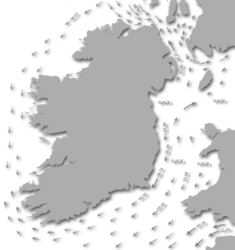
Ballycotton Bay is a good anchorage in all westerly conditions, with excellent holding. The area is open to the east and somewhat affected by winds with a northerly component. Strong southeasterly and southerly conditions also send heavy rollers into the bay, making it highly uncomfortable. Access is straightforward as there are no off-lying dangers impeding approaches from the east.

Keyfacts for Ballycotton
Facilities


Nature


Considerations
Protected sectors

Approaches

Shelter
Last modified
July 19th 2023 Summary
A good location with straightforward access.Facilities
Nature
Considerations
Position and approaches

Expand to new tab or fullscreen
Haven position
 51° 49.700' N, 008° 0.040' W
Ballycotton Harbour's eastern pierhead by the entrance.
What is the initial fix?
The following Ballycotton initial fix will set up a final approach:
 51° 49.954' N, 007° 57.994' W


What are the key points of the approach?
Offshore details are available in southeastern Ireland’s Coastal Overview for Rosslare Harbour to Cork Harbour  .
.
.- There are no off-lying dangers impeding approaches from the east to the north of Ballycotton Island.
- The inner, or small, island is connected to the mainland by a drying ridge, and this pass should not be attempted.
- Ballycotton Sound, between the inner island and the outer Ballycotton Island, with a lighthouse, may be used, but beware of Sound Rock.
Not what you need?
Click the 'Next' and 'Previous' buttons to progress through neighbouring havens in a coastal 'clockwise' or 'anti-clockwise' sequence. Below are the ten nearest havens to Ballycotton for your convenience.
Ten nearest havens by straight line charted distance and bearing:
- Knockadoon Slip - 6.1 nautical miles NE
- Aghada - 7.8 nautical miles W
- Northeast of Great Island - 8.1 nautical miles WNW
- East Ferry Marina - 8.2 nautical miles WNW
- White Bay - 9.5 nautical miles W
- Youghal - 9.5 nautical miles NE
- Cuskinny - 10 nautical miles W
- Spike Island - 10.8 nautical miles W
- Cobh - 11.1 nautical miles W
- Crosshaven - 11.2 nautical miles W
These havens are ordered by straight line charted distance and bearing, and can be reordered by compass direction or coastal sequence:
- Knockadoon Slip - 6.1 miles NE
- Aghada - 7.8 miles W
- Northeast of Great Island - 8.1 miles WNW
- East Ferry Marina - 8.2 miles WNW
- White Bay - 9.5 miles W
- Youghal - 9.5 miles NE
- Cuskinny - 10 miles W
- Spike Island - 10.8 miles W
- Cobh - 11.1 miles W
- Crosshaven - 11.2 miles W

Chart

What's the story here?
 Ballycotton Harbour extending northward from Ballycotton Point
Image: Michael Harpur
Ballycotton Harbour is a small artificial harbour situated on the southwestern side of Ballycotton Bay. It is entered between Ballycotton Island and Knockadoon Head to the northeastward. The harbour is located on the north side of Ballycotton Point, which is close west of Ballycotton Island and has a sizable village overlooking it from the rocky cliffs above. It is formed by a 150-metre-long eastern pier that extends northward from the point, and the enclosing arm of a breakwater that extends eastwards towards the head of the pier, leaving an entrance that is 25 metres wide. The area within is predominantly used by fishing boats and a lifeboat.
 Ballycotton Lifeboat Station overlooking the harbour
Image: Michael Harpur
Outside the breakwater and immediately to the northwest of the harbour entrance are six big yellow visitor mooring buoys, or you may anchor clear of the harbour fairway nearby.

It is also possible to enter the harbour, but it is subject to silting, and depths alongside the wall should be conservatively considered to be 1.5 metres LAT unless better information is obtained. It is not overly attractive, being space-constrained and busy with fishing boats, while the wall is of rough corrugated iron. Hence picking up moorings or anchoring outside the harbour is the better option for visiting boats. The harbour is managed by the East Cork Harbour Master Liam Keating (including Youghal Harbour),
 +353 (0)24 929 26, Ext: 8610,
  +353 (0) 86 780 08 78,
  Liam.Keating@corkcoco.ie.
How to get in?
 Ballycotton Island as seen from the east
Image: John Finn
 Use the southeastern Rosslare Harbour to Cork Harbour coastal overview for seaward approaches. Ballycotton Bay is entered between Ballycotton Island and Knockadoon Head about 5½ miles eastward. At its head is a fine beach of sand extending in a bold semi-circular sweep for nearly 4 miles. The bay is sheltered to the south by two islands, of which Ballycotton Island, with a lighthouse, is the outer. The inner, or small, island is connected to the mainland by a ridge of rocks that uncovers on the last quarter ebb.
  Ballycotton Sound as seen from the south
Image: Burke Corbett
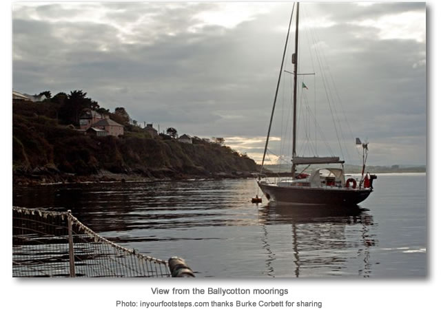
Ballycotton Sound lies between the two islands and there is a passage available between them. This lies to the west of the outer Ballycotton Island and to the east of the covered and only occasionally awash Sound Rock, which extends out from the inner island. This reduces the pass to about 150 metres wide, carrying about 4 metres of water. Tidal currents can attain 2 knots in Ballycotton Sound and it should not be attempted in any southwesterly conditions.
 Ballycotton Sound as seen from the west
Image: Michael Harpur
Newcomers to the area approaching from the west are best advised to avoid Ballycotton Sound and round the outer Ballycotton Island to make an eastern approach. However, in fair weather with good visibility, this cut may be used by staying between 150 metres and 100 metres from the outer island (with lighthouse) to keep to the east of the Sound Rock. The outer island should not be approached any closer on account of skirting rocks on its western side.
 Approaching to the north of Ballycotton Island
Image: Burke Corbett
 The initial fix is within Ballycotton Bay and assumes a vessel has either arrived from the east or via a western approach that rounds to the south and then east of Ballycotton Island. Those rounding the island should stand at least ¼ mile at all times.
 Proceeding in from the Ballycotton initial fix will take a vessel past the north side of both islets. The eastern pier of the harbour will be clearly visible all the way across the bay.
 Ballycotton Harbour entrance and visitor buoys
Image: Michael Harpur
The harbour's six big yellow mooring buoys will be seen outside the breakwater immediately to the northwest of the harbour entrance. The moorings are rated to 15 tons and are large, coloured bright yellow and labelled ‘VISITOR’. Land at the lifeboat station slipway or the beach at the head of the harbour. Ballycotton Harbour's entrance
Image: Michael Harpur
Vessels may also proceed in through the harbour's 25-metre wide north-facing entrance, where 3.7 metres will be found. There is limited water alongside, with a best depth of 1.5 metres LWS. The harbour shelves to the south, where it dries entirely. It is subject to a heavy ground swell in southerly winds and is not lit.
 Boats moored in the centre of the harbour within the entrance
Image: Michael Harpur
Pier space is highly constrained and the walls are made of rough steel-pile shuttering, so a fendered plank is essential to protect the topsides. There are no convenient rings in the walls to take a warp, so vessels coming alongside will need someone ashore to take the lines. As the walls are high, the only usable berth is off the steps. The best berthing arrangement will be to raft up alongside a fishing boat that has no plans to depart in the near future.
 Ballycotton's wall is usually occupied with local fishing boats
 Image: Michael Harpur
Vessels may anchor anywhere in the outer bay that affords good shelter as a whole. The soundings are regular and shoal gradually from about 15 metres abreast of the lighthouse, to 5 metres at ½ mile from the western shore. The bottom has very good holding ground, being sand over mud and clay. Very little sea comes in between the islands when there is any western component in the wind, even at high water. But with any winds from the east of south, a heavy sea rolls in.
Why visit here?
The name Ballycotton is from the Gaelic Baile Choitín. The Irish words comprise the commonly used term Baile, meaning 'townland', with Coitín or possibly the Old Irish Coitchend, which carry the general meaning of 'common land, publicly owned/shared'. The name Ballycotton, or Baile Choitín, would therefore mean 'the townland of the common area/commonage'. Ballycotton village perched on a hill leading down to the harbour
Image: Michael Harpur
History of human inhabitation runs deep here, with late Mesolithic stone tools found along the coastline from Roche's Point to Ballycotton. These early inhabitants would not have overlooked Ballycotton’s natural advantages of being nestled in the southwestern corner of a bay that affords safe landings with an anchorage and general protection from prevailing westerly winds. It would have been used by the nation’s earliest mariners from prehistoric times. It is believed the vicinity of the headland hosted two Iron Age coastal promontory forts, one of which was connected by a small track/road to the point. These could have been used on and off into the early medieval period, when it would have continued to serve as a landing point and route for seasonal trade and exchange. These attributes were noted later on several European maritime maps from the 14th to the 16th centuries. It was most likely that it was this trade that led to the area been marked in history by the discovery of a 9th-century jewelled Celtic cross.
 Inhabited since the Mesolithic period, the coast was the site of two promontory forts
Image: Michael Harpur
Known as the 'Carolingian Brooch' or 'Ballycottin Cross', it has been documented in the British Museum as “said to have been found in or near Ballycotton Bog”. The cross has a central glass jewel with an inscription of the Bismillah in Kufic script, which may be interpreted as meaning 'As God wills' or 'In the name of Allah', or possibly 'We have repented to God'. In 1875 local antiquarian Philip T Gardner donated the Ballycotton cross to the British Museum, where it is located today in the museum's brooch collection. The cross is seen as an early indicator of links between Ireland, Britain and early Islam, and has been cited in academic papers and histories of Islam's presence in the late Dark Ages within northern Europe.
 The harbour developed from a coastguard station
Image: Michael Harpur
The modern harbour seen today stems from the establishment of a series of coastguard stations in the early 1800s to combat smuggling and carry out search and rescue operations at sea. This was one of the five stations of the coastguard comprised within the district of Youghal. First edition OS maps show a small village and coastguard station at Ballycotton village, which was subsequently developed into the harbour of today. Around this a number of fishermen’s cottages grew and so the village developed. The current village is a resettlement of an older village that is now entirely underwater as the area experiences severe coastal erosion, with several metres of land crumbling into the sea every few years.
 The tower on Capel Island
Image: John Finn
Ballycotton Island’s lighthouse is the hallmark of the haven, but the tower on Capel Island, situated 6 miles to the east, predates it. In the early 19th century, the Ballast Board recommended a lighthouse should be installed on Ballycotton Island, as well as Mine Head, to protect this length of the coast. But Cork’s merchants and ship owners vehemently disagreed and spent 19 years lobbying to have a lighthouse built on Capel Island instead. Finally they got their way, and in 1847 a reluctant Ballast Board began the construction of Capel Island lighthouse. The dispute kept the authorities in a malaise and the east Cork coast dark for years on end. It was Cork’s merchants and ship owners who would pay the price with one of their own world-famous vessels.
 SS Sirius
Image: Public Domain
 Capel Island with Ballycotton Island in the background
Image: Burke Corbett
The same Cork merchants and ship owners then humbly appealed to the Ballast Board for a lighthouse to be established on Ballycotton Island and Mine Head. The unfinished works on Capel Island works were completed at two storeys and then capped. It was finished off as an unlit beacon, which if required at a later date, could be made into an outer harbour light for Youghal.
 Ballycotton as seen from the Smith’s Buoy
Image: Burke Corbett
Then work started on Ballycotton Island by ‘topping’ the very steep island, like a boiled egg, to get a flat surface on which to build. By July 1849 the tower was ready to take the cut stone lantern blocking. By March 1850 the bulk of the building had been completed and the dome of the tower was being sheeted with copper. The 15-metre tower was completed in 1851, when the light was first lit.
 Ballycotton Light
Image: John Finn
The original Ballycotton Island lighthouse keeper and his family lived on the island, the children rowing ashore to school when weather permitted. By 1899 the lighthouse’s four keepers were housed in the town with the keepers rotating lighthouse duty. In 1975 the light was converted to electricity and it was automated in 1992, when the lighthouse keepers were withdrawn. Ballycotton Lighthouse is very unusual being a black tower. It is one of only three black lighthouses in the world, the others being in Australia and Texas. This dates back to 1902, when it was painted black to help distinguish it from the white Capel Island tower.
 Capel Island and Knockadoon Head, with Ballycotton Island in the background
Image: John Finn
Today Ballycotton is a small, quaint and picturesque fishing village perched on a rocky ledge.
It is now most noted for its 9km scenic cliff walk extending westward to Ballytrasna, the location of one of its ancient promontory forts. The ‘goat-track’ walk has occasional safety fencing, as required, and bench seats placed at the better viewing points. The walk provides excellent opportunities to take photographs of the cliffs and seascapes. It also offers a good chance of spotting peregrine falcons near the rocky inlets at dawn and dusk. Wildlife is truly plentiful in the area, with seals and dolphins being regular harbour visitors. The nearby beach at Ballynamona is part of a wildlife sanctuary, with herons, oystercatchers and sandhoppers regularly spotted.
 Yacht on moorings off of the east breakwater
Image: Tourism Ireland
Alongside this wildlife, many artists and craftspeople, including woodworkers, painters, potters, writers and musicians who regularly exhibit at the Stephen Pearce Gallery in Shanagarry, live in this area. Several big names in entertainment have chosen the relative seclusion and natural beauty of Ballycotton for their home. These qualities sit alongside many fine public houses that have excellent traditional music. This concentration of artists has led to the village hosting an annual arts festival called the 8 Degrees West Arts Festival. Held on the first weekend of June, it is named after the line of longitude that runs between the island and the mainland.
 Dusk at Ballycotton Harbour
Image: Tourism Ireland
From a sailing perspective, Ballycotton provides an excellent anchoring location with ample to explore for a stopover. Being just a small divergence from the coastal passage, it also makes a very useful passage stopover for a lunch break or for vessels looking to turn in for the night.
What facilities are available?
Fresh water is available from a tap on the pier, plus modest usage of electricity is permitted at the seaward end of the south jetty. There is a bar above the moorings that often has traditional music. The small village, situated about 20 minutes’ walk away, offers basic provisioning, a post office and three bars. One of the bars serves food and there is also a restaurant. Ballycotton is situated about 25 miles east of Cork city and is serviced by three buses a day to Midleton.Any security concerns?
Never an issue known to have occurred to a vessel anchored or on moorings off Ballycotton.With thanks to:
Burke Corbett, Gusserane, New Ross, Co. Wexford. Photographs: With thanks, litlg, Finbar Cotter, David Pickersgill, Michael Harpur and Burke Corbett, plus a very special thank you for the beautiful images of John Finn.


An aerial view of Ballycotton Harbour
An aerial view of Ballycotton Harbour and the bay
Ballycotton Island


Add your review or comment:
Please log in to leave a review of this haven.
Please note eOceanic makes no guarantee of the validity of this information, we have not visited this haven and do not have first-hand experience to qualify the data. Although the contributors are vetted by peer review as practised authorities, they are in no way, whatsoever, responsible for the accuracy of their contributions. It is essential that you thoroughly check the accuracy and suitability for your vessel of any waypoints offered in any context plus the precision of your GPS. Any data provided on this page is entirely used at your own risk and you must read our legal page if you view data on this site. Free to use sea charts courtesy of Navionics.